


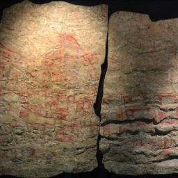
The wall painting on ruins in the 9000 years old Turkish village Çatalhöyük has been made in a period in which an erruption took place of the nearby positioned vulcano Hasan Dağı.
With that it has become more attractive that the rather unclear image pictures a street map of the village during the vulcano erruption like some scientists already has suggested.
Rocks
The scientists collected pumice stone of the now inactive vulcano and used two date methods to decide when the different layers of rock on the mountain were formed by the erruption.
The research pointed out that the vulcano came to erruption about 6.600 before Christ. The wall painting is likely to also have been made around that time.
"The erruption took place in the tame that there lived people in Çatalhöyük," explains head researcher Axel Schmitt on NPR News. "We can say that without hesistating."
History
The finding suggests that the wall painting indeedly is an image of the village, made during the erruption, according to Schmitt. That would also immediately make it one of the oldest known maps.
"Vulcanic erruptions are very impressive. Maybe the idea that the vulcano was part of the history of the village dominated."
Even Keith Clarke, an independent American expert on the area of historic land maps, finds the study convincing. "We cannot say it with 100 percent certainty, but I think that there more and more evidence suggests that indeed it is about a map."
Leopard
There are also alternative theories. So do researchers of the University of Cambridge suspect that the wall painting doesn't picture a map, but the skin of a leopard.
